
Kansas Map
 |
 |
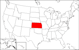
Where Is Kansas?
The map to the right displays the location of Kansas in red. The State of Kansas is bounded by Nebraska on the north and by Oklahoma on the south. Kansas is bordered on the east by Missouri and on the west by Colorado.
Kansas Maps
Kansas is the 13th largest state in the United States, covering a land area of 81,815 square miles (211,901 square kilometers). Kansas is divided into 102 counties, and several metro areas are located in eastern Kansas. This Kansas map site features road maps, topographical maps, and relief maps of Kansas. The detailed, scrollable road map displays Kansas counties, cities, and towns as well as Interstate, U.S., and Kansas state highways. The pannable, scalable Kansas street map can be zoomed in to show local streets and detailed imagery.
Kansas Highway Map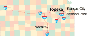 Click on the highway map thumbnail
to view a scalable Kansas road map. |
KS Topo Map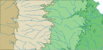 Click map to enlarge.
|
KS Relief Map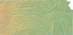 Click map to enlarge.
|
The detailed Kansas map and the regional Kansas map display cities, roads, rivers, and lakes as well as terrain features. The detailed map shows only the State of Kansas, while the regional map shows Kansas and the surrounding region.
Kansas Infrastructure > Kansas Airports
In 2005, the population of Kansas was estimated at 2,748,172, which is about 33.5 people per square mile. In 2010, Kansas' population rose to 2,853,118 people. More recently, in the 2020 census, the Kansas population was 2,937,880. The state's Interstate Highways include I-35 and I-70 as well as auxiliary routes I-135 and I-335. The only major Kansas airport is the Wichita Mid-Continent Airport.
Kansas Topography and Historic Sites
The name Kansas is derived from the Sioux word Kansa, which means "people of the south wind". The Kansas landscape gradually rises from low prairie terrain in the east to high plains in the west. The Kansas, Arkansas, Smoky Hill, and Neosho Rivers run through Kansas and drain the land. Tourist draws include the Eisenhower Center, Dodge City, and the Fort Scott National Historic Site. Visit the official Kansas tourism site and Kansas Atlas for additional Kansas travel and tourism information.
Other Kansas Maps
This online Kansas reference map shows major cities, roads, railroads, and physical features in Kansas.Several map publishing companies offer printed maps of Kansas. For example, Omni Resources offers several maps of Kansas that feature points of interest, airports, and parks, as well as selected local attractions and insets of major Kansas cities.
All rights reserved.
Certain maps hereon are © Map Resources or Digital Wisdom.
To facilitate browsing, certain external links will open in new windows.
Kansas-Map.org Editor, State Maps, PO Box 828, Barnegat, NJ 08005.