
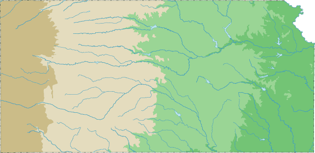
Kansas Topographical Map
Static Kansas Topo Map
This section features a topographical map of Kansas as well as a map legend that specifies elevation ranges and indicates their corresponding map colors.
Map Legend |
 |
|
 |
Kansas Topographical Features
Kansas's highest mountain is Mount Sunflower, whose peak is 4,039 feet above sea level. Kansas's lowest elevation is 679 feet above sea level, at the Verdigris River. Kansas is a prairie state, whose elevation rises gradually from the Mississippi river valley in the east to the high plains in the west. The fertile plains of eastern Kansas are quite hilly. Major rivers in Kansas include the Kansas, Arkansas, Big Blue, Republican, Solomon, and Saline.Interactive Kansas Topo Map
This section features a topographical map that can be zoomed and panned to show the entire State of Kansas or a small portion of the state. To zoom in or out on the map, use the plus (+) button or the minus (-) button, respectively. To pan the map in any direction, simply swipe it or drag it in that direction. At high zoom levels, the contour lines on this Kansas map can help outdoorsmen, land developers, and others to plan their routes and activities more efficiently.
Copyright © 2005-2024 State-Maps.org. All rights reserved.
Kansas-Map.org is a State Maps reference source.
Kansas-Map.org is a State Maps reference source.